Update info

Updated every Friday.

Tuesday, November 26, 2019

26th November

What happened this week?

What Does Flash Drought Look Like in Your Region? The overall goal of the research was to explore seasonal characteristics of flash droughts within the growing season, which runs primarily from March or April to October, and how they vary across the United States. Specifically, the analysis focused on quantifying the timing, intensity, preceding conditions, and the likelihood of persistence of flash drought to hydrological drought. To quantify the regional characteristics of flash drought events, the study focused on nine climate regions across the United States grouped by their climatologically similar characteristics. ..Read more


Interesting Facts


Types of drought. Research in the early 1980s uncovered more than 150 published definitions of drought. The definitions reflect differences in regions, needs, and disciplinary approaches. Wilhite and Glantz categorized the definitions in terms of four basic approaches to measuring drought: meteorological, hydrological, agricultural, and socioeconomic. The first three approaches deal with ways to measure drought as a physical phenomenon. The last deals with drought in terms of supply and demand, tracking the effects of water shortfall as it ripples through socioeconomic systems..Read more


Drought leaves Chilean growers in limbo. Almost 90 percent of Chilean fruit producers believe they face a fragile or unsustainable future because of the drought affecting large swathes of the country, according to a survey by fruit producer federation Fedefruta. The survey, entitled ‘Impact of Drought on Chilean Fruit Production’, was created to assess the perception of growers in the country’s main fruit-producing regions. Releasing the results last week, Fedefruta said it had collected 375 responses from growers from Atacama to Los Lagos..Read more


Long-Term Drought Parches Chile. Central Chile, where most Chileans live, has received 30 percent less rainfall than normal over the past decade, a situation that scientists are referring to as “megadrought.” With rainfall deficits of 80 to 90 percent, 2019 has been particularly. The map above depicts the Normalized Difference Vegetation Index (NDVI), a measure of the health and greenness of vegetation based on how much red and near-infrared light it reflects... Read more


What Panama’s Worst Drought Means for Its Canal’s Future. A severe drought in Panama has resulted in lower water levels in the Panama Canal, forcing some shippers to limit the amount of cargo their largest ships carry so they can safely navigate the waterway. “The last five months have been the driest dry season in the history of the canal,” said Carlos Vargas, the Panama Canal Authority’s executive vice president for environment, water, and energy... Read more


Policy Developments and Outlook


Migration in Central America and the Case of the Northern Countries. Poverty is indeed a crucial driver, particularly in Honduras and Guatemala, where it affects about 70% of the overall population. Environmental or climatic factors are also playing an increasingly central role in increasing migration flows. In the past few decades, northern CA countries were in fact hit by hurricanes, earthquakes, and drought, increasing the vulnerability of the population (especially in rural areas). The rural poor are the most vulnerable to economic, political and even environmental crises due to the very high levels of vulnerability of the agricultural sector. They represent 82% of the population in Honduras, 77% in Guatemala and 49% in El Salvador. Moreover, about 34% of the labor force in Guatemala and Honduras works in agriculture. Read more


In Honduras, Communities Fight Drought With Watershed Work. “The purpose of the Dry Corridor Alliance is to reduce poverty in the Dry Corridor region through the implementation of three components: focus on agriculture productivity, watershed management, and food security,” said Marco Tulio Mejia, a technical field officer with the alliance. “All of that is linked to one fact, which is the water.”... Read more


Latin America and the Caribbean’s Drought Atlas. The occurrence of droughts in Latin America and the Caribbean has had devastating impacts on vulnerable communities in the region, generating severe social, economic and environmental impacts when they extend over time. Therefore, knowing the recurrence of these events is essential to be able to anticipate these threats and to put concrete policies and measures to address them... Read more


Friday, November 15, 2019

Special Edition: From relief to development


International cooperation on humanitarian assistance in the field of natural disasters, from relief to development - Report of the UN Secretary-General. The present report is submitted under General Assembly resolution 73/136, in which the Assembly requested the Secretary-General to continue to improve the international response to natural disasters and to report thereon to the Assembly at its seventy-fourth session. The period covered in the report is 1 January to 31 December 2018. The report provides an overview of progress made in this regard and outlines related trends, challenges, and thematic issues. It concludes with recommendations for further improvements... Read more.

Strengthening Disaster Preparedness in the Caribbean. Disaster preparedness and management agencies are using better tools and improving their effectiveness in every country in the region. But Dorian has shown us that adapting to climate change also requires a concerted response from the international development community, since the scale of preparedness, relief, recovery and rebuilding efforts countries and communities need to carry out are beyond the scope of national and regional budgets....Read more.

Interesting Facts

Danger still lingers two years after Colombia's deadly Mocoa landslide. Two years after a mudslide that killed more than 300 people in the Colombian rainforest town of Mocoa, local authorities are struggling to get the funds to resettle tens of thousands of residents living in areas at risk of flooding. Torrential rains on March 31, 2017, triggered a deadly torrent of mud, debris, and rocks, and caused rivers to burst their banks, washing away entire neighborhoods...Read more.


The earthquake of September 19th in schools in Mexico City.
Three weeks after the earthquake, the authorities of four Regions (Juarez, San Lorenzo Tezonco, San Miguel Teotongo, and Centro) summoned the school supervisors to meet. The first proposal given by the government was to install prefabricated classrooms, but days later the authorities reported that there were no resources for it and that they should seek other solutions ...Read more.


How an Architect Who Designs ‘Half-Houses’ Rebuilt a City. Elemental was asked to devise a rebuilding plan for the city in 100 days, working alongside engineers and consultants. Half-houses were built, but later on; first came a robust (though compressed) public dialogue that changed assumptions about what “disaster recovery”...Read more.

How the Waste and Recycling Industry Prepares for Natural Disasters. When a natural disaster is on its way, the first thing haulers and municipal solid waste (MSW) departments do is put safety first. From checking in with employees to alerting local communities of safety tips and service changes, precautions are taken to prepare not only waste and recycling industry workers but the members of communities that may be affected by natural disaster-related dangers and service disruptions...Read more.


Policy Developments and Outlook


FONDEN: Mexico’s National Disaster Fund Every year, federal and state governments in Mexico spend close to US$1.5 billion on the reconstruction of public assets and low-income housing after natural disasters. In 2010 alone, major floods required over US$5 billion, mostly for local assets. In response to the continued need for ex-post budget reallocations, the Government of Mexico (GoM) established the Fund for Natural Disasters (FONDEN) in 1996. Its original mandate was to provide adequate financial resources for federal and state reconstruction efforts without compromising committed government spending...Read more.


Climate Disasters Are Getting Worse. Here's How Developing Countries Are Insuring Against Them. To help countries cope with disaster, new tools have emerged over the last decade, including sovereign parametric insurance. Though currently underutilized, this kind of insurance has a key role in helping countries manage the risk of climate-related and other disasters, particularly when the risk is pooled among many nations. Climate disasters will happen—the only question is whether developing countries will have the tools they need to recover and rebuild, ideally with greater resilience...Read more.

Tuesday, November 5, 2019

Special Edition World Tsunami Awareness Day


About World Tsunami Awareness Day. In 2019, the World Tsunami Awareness Day will promote Target (d) of the "Sendai Seven Campaign" which focuses on reducing disaster damage to critical infrastructure and disruption of basic services. Over 700 million people live in low-lying coastal areas and Small Island Developing States exposed to extreme sea-level events including tsunamis (IPCC).. Read more


Onagawa's spirit of togetherness: lessons from the 2011 tsunami The date for the annual celebration was chosen in honour of the Japanese story of Inamura-no-hi, or the “burning of the rice sheaves”. The story comes from an earthquake that shook the region in 1854, when a farmer set fire to his entire harvest to warn villagers of the tsunami when he saw the tide receding. The villagers fled to higher ground and later planted trees as an embankment for the future.. Read more


World Tsunami Awareness Day. Tsunamis are rare events, but can be extremely deadly. In the past 100 years, 58 of them have claimed more than 260,000 lives, or an average of 4,600 per disaster, surpassing any other natural hazard. The highest number of deaths in that period was in the Indian Ocean tsunami of December 2004. Read more


Interesting Facts


What are Tsunamis?. Tsunamis are ocean waves triggered by large earthquakes that occur near or under the ocean, volcanic eruptions, submarine landslides, and by onshore landslides in which large volumes of debris fall into the water. Scientists do not use the term "tidal wave" because these waves are not caused by tides. Tsunami waves are unlike typical ocean waves generated by wind and storms, and most tsunamis do not "break" like the curling, wind-generated waves popular with surfersx... Read more


How large can a tsunami be in the Caribbean?. "It's been a long time since a big earthquake and tsunami have hit the region, but almost 3500 people have lost their lives in the past 500 years from tsunamis in the Caribbean," said von Hillebrandt-Andrade. "The vulnerability is just huge because so much of our population and infrastructure is located right along the coast.".... Read more


Historical Tsunamis Worldwide. The list below shows a selection of major tsunamis with notable scientific or cultural impact that have happened in recorded history... Read more


Policy Developments and Outlook


DNR Releases New Maps to Help Residents Walk to Tsunami Safety. “We’ve seen around the world how devastating tsunamis are for coastal communities,” said Commissioner of Public Lands Hilary Franz, the elected official who leads DNR. “In the event of a tsunami, nothing is more important than knowing where to go to be safe and how long it will take to get there. That is why Department of Natural Resources’ geologists are making this life-saving information easily accessible for everyone who lives, works or plays along Washington’s coast.”... Read more


EDUCATIONAL MATERIAL: Earthquake and tsunami textbooks and teacher guides, The tsunami textbooks are divided into four levels. Pre-Elementary school, 2nd to 4th grade, 5th to 8th grade and High School. These levels correspond to the school levels found in Chile: the first level is similar to pre and kindergarten, the second and third level correspond to the first eight years of school and the fourth level to High School. Each text book has its own teacher guide. Read more

Friday, November 1, 2019

November 1st, 2019

What happened this week?


Longer, More Frequent Fire Seasons. new analysis of 35 years of meteorological data confirms fire seasons have become longer. Fire season, which varies in timing and duration based on location, is defined as the time of year when wildfires are most likely to ignite, spread, and affect resources. In the map above, areas where the fire season lengthened between 1979 and 2014 are shown with shades of orange and red. Areas where the length of the fire season stayed the same are yellow. Shades of blue show where the fire season grew shorter. Gray indicates that there was not enough vegetation to sustain wildfires...Read more.


Interesting Facts

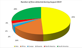
Is Earth on fire? Wildfires have been making headlines again this month, with multiple fires burning in Lebanon and California, but these are just some of the many fires 2019 has seen. Fires in the Amazon sparked a global outcry this summer, but fires have also been blazing in the Arctic, France, Greece, Indonesia as well as many other areas in the world. Quantifying and monitoring fires is important for the ongoing study of climate because they have a significant impact on global atmospheric emissions, with biomass burning contributing to the global budgets of greenhouse gases, like carbon dioxide.... Read more


A Forest Expert Team In Spain Fights Fire With Fire — Literally. Fires in California and the Amazon rainforest have grabbed attention, but large areas of Europe's forests also were consumed this summer. Blazes nearly the size of the one in Catalonia tore through Spain's Canary Islands, the south of France and the Greek islands of Evia and Samos. 
"We need to learn to live with fire, the same way we do with tornadoes or snowstorms", says Marc Castellnou, chief analyst for a special forest unit of Catalonia's fire services, known by its Catalan initials GRAF... Read more


What California Stands To Learn From Indigenous Fire Management Practices. For 13,000 years, many Indigenous tribes, including the Hupa, Karuk, Miwok, and Yurok lit controlled fires across northern and central California. This created a mosaic of habitats with a high diversity of species that California is known for today. Through multiple progressions of these practices, many species, such as acorns and huckleberries became associated with these deliberate, low-intensity fires. Despite their fire resistance, they are ill-equipped to tolerate the high-intensity nature of modern wildfires in California... Read more


Policy Developments and Outlook


Fire in Yellowstone. Fire has been a key factor in shaping the ecology of the Greater Yellowstone Ecosystem. Native plant species evolved adaptations so they survive and, in some cases, flourish after periodic fires. Fire influences ecosystem processes and patterns, such as nutrient cycling and plant community composition and structure. Fire regimes in the western United States changed with the arrival of European and American settlers, whose livestock removed grassy fuels that carried fires and whose roads fragmented the continuity of fire-carrying fuels. Most naturally occurring fires were suppressed to the extent possible. The National Park Service aims to restore fire’s role as a natural process in parks when and where this is feasible... Read more